1/11


My Elevation
1K+下载次数
13.5MB大小
1.79(20-01-2025)最新版本
详情评价版本信息
1/11
My Elevation介绍
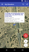
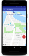
我的海拔使用网络服务根据您当前的位置获取精确的表面海拔。 这比您的设备提供的海拔数据准确得多。 但您还可以使用“我的海拔”做更多事情。 尝试一下看看!
注释:
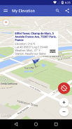
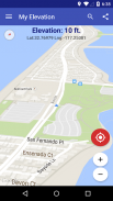
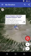
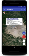
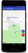
● 该应用程序根据纬度和经度显示海拔
海拔
。 当您在飞机上、建筑物高处或由于某种原因远离地面时,它不会提供
高度
。
● 此应用程序必须具有有效的数据连接才能在地图上显示您的位置、获取精确的海拔并提供更多附加的丰富内容。 它没有离线模式。当您在没有数据连接时无法工作时,请在给予差评之前考虑这一点。
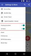
功能列表
● 跟随我模式 - 实时跟随您当前的位置。 在地图上观察您的移动,并在您移动时查看您的海拔和坐标的更新。
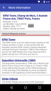
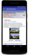
● 搜索位置并观看地图飞向它们。我的海拔会告诉您那里的天气,并让您浏览有关该位置附近景点的维基百科文章。如果您对其他地方感到好奇,您一定会喜欢这个!
● 长按地图上的某个位置,“我的海拔”将告诉您那里的天气,并让您浏览有关该位置附近景点的维基百科文章。
● 为您想要记住的地方添加书签。
● 通过短信或电子邮件与朋友分享您的位置或搜索结果。
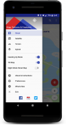
显示选项
地图模式 - 让您选择四种 Google 地图类型之一(普通、卫星、地形和混合)
航向向上、地图倾斜和夜间模式
尝试一下,让我们知道效果如何。
给我们发电子邮件 support@rdhsoftware.com
或访问 https://www.facebook.com/MyElevation
该应用程序使用 Google Analytics 收集有关应用程序如何使用以及发生什么故障的匿名数据。 这使我们能够在每个版本中使应用程序变得更好。 您可以通过取消选中应用程序首选项中的分析数据项来选择退出。 不会收集任何个人身份信息。
My Elevation - 版本1.79
(20-01-2025)新特性Edge to Edge Main Display.Support for Android™ 15.Bug Fixes.
My Elevation - APK信息
APK版本: 1.79程序包: com.rdh.mulligan.myelevation名称: My Elevation大小: 13.5 MB下载次数: 594版本: 1.79发布日期: 2025-04-27 16:34:48最小屏幕: SMALL支持的CPU:
程序包ID: com.rdh.mulligan.myelevationSHA1签名: 9E:00:3D:F0:7E:9D:0B:75:0B:67:BF:75:C2:34:BF:8A:23:53:7B:0E开发商 (CN): 组织 (O): RDH Software本地 (L): 国家/地区 (C): 州/市 (ST): 程序包ID: com.rdh.mulligan.myelevationSHA1签名: 9E:00:3D:F0:7E:9D:0B:75:0B:67:BF:75:C2:34:BF:8A:23:53:7B:0E开发商 (CN): 组织 (O): RDH Software本地 (L): 国家/地区 (C): 州/市 (ST):
My Elevation的最新版本
1.79
20/1/2025594 下载次数13 MB 大小
其他版本
1.78
11/1/2025594 下载次数13 MB 大小
1.77
20/11/2024594 下载次数13 MB 大小
1.62
9/11/2020594 下载次数5.5 MB 大小
1.44
5/9/2018594 下载次数5 MB 大小
1.41
21/7/2018594 下载次数4.5 MB 大小


同类应用

您可能还会喜欢……

English


